30 May 2008
We got off pretty early this morning, which was nice. We rode from Carson City to Fallon, NV. Mary and the rest of the family weren't there yet, so after checking out the campground we rode a bit further to get a head start on tomorrow. They came and picked us up about 10 or 12 miles out of Fallon. We rode 77 miles today.
Sunday, June 1, 2008

day 4
29 May 2008
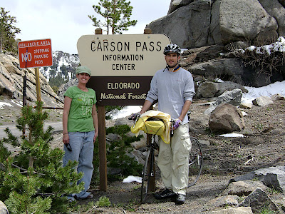
We did a lot of downhill today. We finished the last of the climb up to Carson Pass, and then down the other side. We stopped in Carson City. We had hoped to go further into Dayton, but we were pretty tired and the wind was blowing us all over the road. At one point we just stopped and hid behind a sign for 15 minutes or so to let the storm pass a bit. We rode 58 miles.
We did a lot of downhill today. We finished the last of the climb up to Carson Pass, and then down the other side. We stopped in Carson City. We had hoped to go further into Dayton, but we were pretty tired and the wind was blowing us all over the road. At one point we just stopped and hid behind a sign for 15 minutes or so to let the storm pass a bit. We rode 58 miles.
day 3
28 May 2008
This will probably be one of the best days of the whole trip. Since the campground we stayed at was so far off the trail, we decided to try a shortcut on a road called the Mormon Emmigrant Drive. Not only did it cut some miles off, it avoided a big downhill section (which would have meant more uphill for the day). The Mormon Emigrant Trail was 25 miles of straight up, but was an amazingly pretty ride. The mossy trees and snow were beautiful. The weather was pretty stormy, but we seemed to follow a lull in the storm the entire way, and didn't get very wet at all. All in all a super day.
We rode 32 miles, and climbed from 3500 to 8000 feet, and then back down a bit to 7300.
day 2
27 May 2008
The first half of todays ride was awesome. There is a bike trail following the river all the way through Sacramento. It was very nice to be away from traffic on a bike route. We rode somewhere around 25 miles on bike trails getting through Sacramento.
After that we had a horrible map day. The directions were very confusing, and we had to backtrack multiple times. The road were busy and the shoulder non-existent, too. When we finally got into Placerville, we were very frustrated and tired. We talked to a really nice guy, Jeff, at Pizza Pro, and he recommended a different route for us. Our campground was quite a ways off the trail, and Jeff said we could take a bike trail and then another road that would take us to the campground and would be shorter. I was sick of the maps by that time, so we decided to try it out. The bike trail was super ... until it turned to dirt. After that we tried to use the GPS to figure out how to get the rest of the way there. Before we could figure it out the batteries died. We were fairly frustrated by then, so we just got on the freeway and rode it because we knew it would get us there. It started pouring on us just as we got to the campground.
So our day started great, and ended not great. We rode 79 miles and climbed to 3500 feet.
day 1
26 May 2008
Today we biked from San Francisco to West Sacramento. We dipped our back tires in the Pacific (the bay, really), and then we took a ferry from San Francisco to Vallejo and headed out from there.
We only took one wrong turn :) which added 16 miles to our total for the day. We ended up going 98 miles.
Sunday, May 25, 2008
in san francisco
We're in San Francisco, and we start riding tomorrow. Today we drove down Lombard Street, checked out our starting point near the Golden Gate Bridge, and visited the Oakland Temple.
Monday, May 12, 2008
a nice saturday ride

My dad and I went for about 40 miles Saturday morning. We went to the top of Traverse Ridge Road. This time we cut over to it on Mike Wier Dr. (we got off Highland Dr. onto Rambling Road, a little after going under the train tracks). I really like that way better. It misses a section of Traverse Ridge Road that has a very thin shoulder.
My dad brought his GPS, just for fun. I was interesting to see the different elevation gains. My dad has been comparing rides that we are familiar with, with climbs that we'll be doing on the trip. It's nice to be able to put some of the sections of the map into terms we can understand. 'On that day, we'll be doing two Millcreek Canyons.' It actually makes me feel better to think of it that way. :)
Subscribe to:
Posts (Atom)

